

(Image credit: UN Geneva, via Flickr)
The usage of technology, to improve humanitarian action and make disaster preparedness and response more efficient, has been increasing in the past number of years. In this final blog post in the series we take a look forward and discuss the possible role that Unmanned Aerial Vehicles (UAV) may have to play in future disaster relief efforts.
Disaster Assessment Teams play a vital role in the earliest phase of a disaster response for a number of reasons including (a) conducting rapid assessments; (b) estimating the scale, severity and impact of the disaster through damage assessment and needs analysis; and (c) reporting on these and the immediate needs of affected peoples. Once the assessment teams are finished with their initial work, disaster relief agencies can effectively mobilise and deploy their teams with the correct tools and skills to the affected regions.
UAVs have started to play an increasing role in such assessment missions in recent years. The ability to gain aerial images of affected regions, often with high-resolution, has aided the rapid and effective response of agencies such as UN OCHA and the Red Cross. A number of examples of the use of remote sensing for humanitarian purposes can be found in the UN OCHA report on World Humanitarian Data and Trends 2014 (page 34 & 35). Reflecting on the recent advancements made in UAV technology, perhaps their most effective use came in the response to Typhoon Haiyan in the Philippines in November 2013. Around the city of Tacloban, a number of different UAV manufacturers teamed up with various NGOs and data analysis teams to help out.
Danoffice IT, from Lausanne, Switzerland, used their Quadcopter to support the humanitarian response in Tacloban. The UAV identified where NGOs could set up camp. Later on, the UAV was used to support a range of additional tasks such as identifying which roads were passable in order to deliver aid and carry personnel. This is a common issue encountered in such situations.
A local Filipino UAV start-up called CorePhil DSI used another UAV to capture aerial imagery of downtown Tacloban, one of the areas hardest-hit by Typhoon Yolanda. 22 GB of images were captured and shared with the Humanitarian OpenStreetMap Team (HOT). Using crowdsourcing, HOT subsequently traced these images to create the most detailed and up-to-date maps of the disaster affected area. These maps were later shared with and used by multiple NGOs as well as the Filipino Government to aid relief efforts. The images taken from the UAV used by CorePhil DSI show a clogged river in Tacloban eight days after the typhoon hit with massive amounts of debris and the same area six weeks later after reconstruction had begun
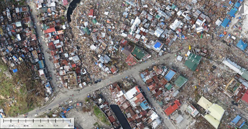
Image taken from a UAV of a clogged river in Tacloban eight days after Typhoon Yolanda hit (Source: Corephil Data Services, Inc., Jeremy Heesu Son.)
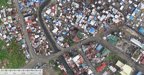
Image taken from a UAV of the same clogged river in Tacloban six weeks later (Source: Corephil Data Services, Inc., Jeremy Heesu Son.)
Despite the usefulness of using UAVs for the purposes outlined above, some humanitarians want to take it further and are starting to use UAVs to search for signals from mobile handsets. The detection of mobile signals can indicate where people may be trapped or injured and the hours immediately after the disaster are the most critical. (A precedent for this has occurred in the past in Turkey, where Turkcell aided emergency responders to rescue 65 people trapped under rubble following an earthquake). One such partnership exists between Disaster Tech Lab (DTL) from Ireland and Sentinel Air from the USA who are researching the use of airborne wireless sensors. They are developing a device which, mounted on a UAV or small plane, could be flown over a disaster-zone to detect and geo-locate signals emitted by mobile phones (Wi-Fi and or cellular signals). The provision of this data in real-time to first responders such as search & rescue teams, fire brigades or ambulance services could save lives.
This new application of such a partnership would exist alongside other services which DTL have been doing since Hurricane Sandy in November 2012; mapping which wireless networks are up and running. This information is fed to NGOs to allow them to co-ordinate relief efforts and critically to avoid over-lapping efforts. ‘’We are very much open to working with operators on these projects as effective search and rescue/initial assessments require combined efforts across multiple stakeholders’’ says Evert Bopp, founder of DTL. The sensor platform is being developed with in-house knowledge by DTL while Sentinel Air is providing the UAV’s aviation knowledge and experience.
As new technologies continue to emerge and develop, and others are repurposed, the potential for impact in humanitarian relief efforts grows.