
Rapidly advancing climate tech offers significant potential to serve as a catalyst for climate action: fostering resilience among the most vulnerable communities, mitigating the primary drivers of climate change, and promoting sustainable management and protection of natural resources, biodiversity, and the environment. However, there is still much to learn when it comes to measuring and attributing the impact of climate tech solutions, and in particular, the environmental impact.
How can we systematically monitor and evidence the environmental ramifications – both intended and unintended – of climate tech innovations? This has been a core part of our work through the GSMA Innovation Fund for Climate Resilience and Adaptation.
The GSMA, with support from the UK Foreign, Commonwealth & Development Office (FCDO) and the Swedish International Development Cooperation Agency (Sida), is working with 12 start-ups across Africa and Asia with a grant under the GSMA Innovation Fund for Climate Resilience and Adaptation. These grants aim to help the piloting, testing and scale-up of sustainable mobile and digital solutions that seek to build climate resilience in vulnerable communities in LMICs.
By working closely with these grantees, we have applied different methodologies to support robust measurement and evaluative assessment of environmental impact of climate tech solutions. This blog presents some of the approaches we tested with our grantees across different sectors and geographic contexts, in five simple, yet practical steps.
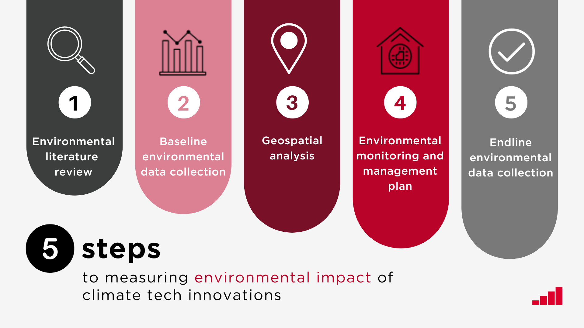
1. Conduct an environmental literature review for your project
A good starting point is to conduct a literature review, i.e. a stocktaking exercise of evidence already available. This can be a swift and low-cost exercise and can help provide a foundational understanding of both the natural environment and the regulatory environment the climate tech solution is situated within.
The analysis could include a review of:
- Scientific and academic literature relating to the environmental impact of the solution
- Publicly available information and datasets on the local environmental context e.g. protected areas or the presence of water bodies
- Local, national and regional environmental legislation and regulatory frameworks
Use this to help decide which environmental indicators to monitor and track. Environmental indicators, such as soil or water quality, are measurable parameters that provide information about the state or quality of the environment, helping to assess and track changes in environmental conditions.
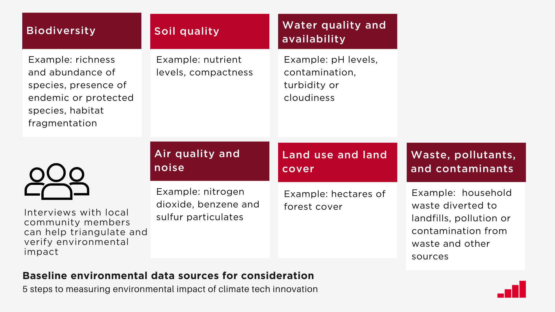
2. Collect baseline environmental data
Establish the baseline environmental context before implementation. A baseline assessment is an initial analysis of the status quo, serving as a starting point for comparison benchmark to track changes or progress over time.
Depending on the project, consider collecting data on the following:

Collecting primary environmental data can be a costly exercise. The literature review should help guide any prioritisation of data collection, and highlight available secondary data sets.
Example: baseline data collection for climate-smart agri solutions
Crop2Cash is a Nigeria based start-up supporting farmers facing drought conditions to manage financial risks with access to:
- Agri-insurance
- Learning content on climate smart farming practices
- High-yield drought resistant maize seeds via USSD

Together with Greenstad consultancy, the GSMA collected baseline environmental data for Crop2Cash. The data highlighted that:
- Soil quality levels within acceptable ranges in farms which use the Crop2Cash service
- There are no significant water body, protected areas or protected species in or around farms which use the Crop2Cash service, and most wildlife has already previously been cleared for farming
- Some of the farmers use harmful pesticides for clearing and preparing the soil for maize, which is an environmental threat
The data gave Crop2Cash a baseline understanding of what the pre-existing farming practices and environmental conditions are, helping to establish the relevance and direction of their project. It also helped the start-up to note which environmental risks exist, which might need to be monitored, and a baseline to compare final project impact against.
3. Use geographic data science to track environmental impact
Geospatial analysis involves examining and interpreting location-based data using remote sensing, geographic information systems (GIS) or other spatial analysis tools. It can be used to track environmental impact as it depicts change within the environment in both time and space scales. Consider using geographic data science tools to monitor the following:
Although it can be highly effective in improving accuracy of analysis and enhancing decision-making with the aid of visual spatial insights, geospatial analysis can be a costly exercise, especially for start-ups. However, access to free or open-source data such as that available on OpenStreetMap (OSM), Natural Earth, and Global Land Cover by Copernicus, with the support of free analysis software such as QGIS (Quantum GIS) can greatly reduce these costs, making this a sustainable way to track environmental impact.
Example: Using geospatial analysis to track impact of sustainable forest harvesting
Dayaxa is a Somaliland based start-up transforming the sustainability of frankincense harvesting through access to:
- Ecological information for local harvesters
- Tree health monitoring
- Mobile blockchain tracing

Together with Arup, GSMA is using geospatial analysis to monitor changes in land use, land-cover, biodiversity, ecosystem health, and conservation practices in frankincense forests in Somaliland. Satellite imagery will be triangulated with other open-source information and ‘on-the-ground’ geographical data obtained through Dayaxa’s app.
We expect the end-of-project final outputs for this geospatial analysis to include visual maps of the environmental impact of Dayaxa’s project, suitable for supporting on decision-making and engaging partners and customers. This should also help to give Dayaxa a clear understanding of what geographical data can or should be collected to demonstrate environmental impact.
4. Develop an environmental monitoring and management plan
An environmental monitoring and management plan is key to providing a systematic framework for tracking, assessing, and mitigating environmental impacts of climate-tech solutions, ensuring sustainable practices, and safeguarding ecosystems. Consider developing a plan to monitor the environmental changes on an ongoing basis and to then manage changes which go beyond a certain threshold.
As part of this, one should conduct a materiality assessment. A materiality assessment is a process of determining and prioritising environmental, social, and governance issues based on their significance and potential impact on a company’s business operations and stakeholders. It can also help clarify which environmental impacts are positive and which are negative. Consider triangulating, analysing and quantifying the positive and negative environmental impacts flagged by the literature review, baseline or geographical data collection.
Develop a plan to monitor and manage both the risks and positive impacts. Consider the following:
- Which impacts are most severe and likely, and therefore a priority to monitor and manage?
- What indicators can be used to track and monitor these changes in the environment? How feasible and affordable is it to do so?
- How will the data be used? What thresholds will trigger a management action, and what will those actions be?
Example: developing an environmental monitoring and management plan for digital fisheries solutions
Aquarech is a Kenya based start-up improving productivity of fish farmers in Lake Victoria through:
- Use of IoT sensors for precision fish farming
- Enabling market access across the fish trade value chain
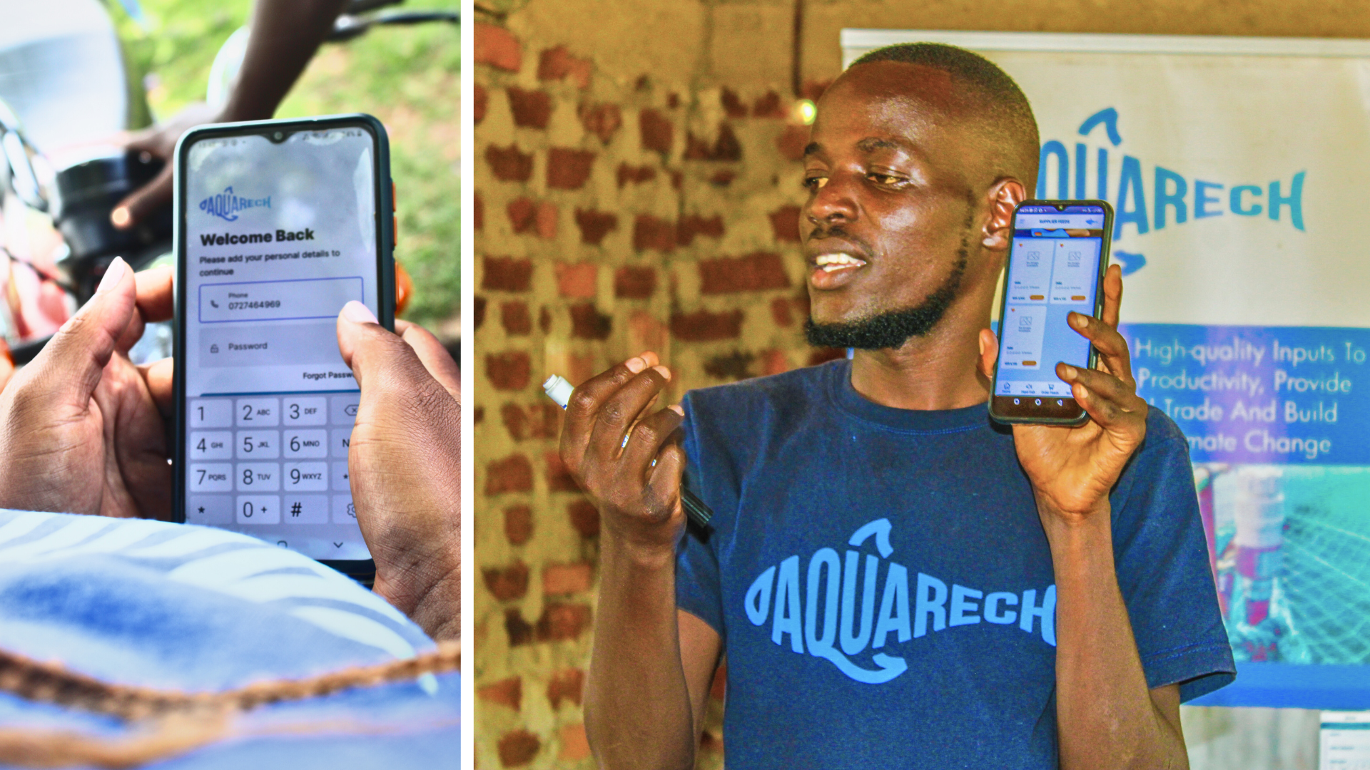
Together with Agramondis, GSMA developed an environmental monitoring and management plan for Aquarech. Some of the actions for Aquarech suggested included:
- Exploring a waste disposal strategy for fish farmers
- Comparing different options for environmentally friendly refrigerants for cold storage of fish
- Expanding training content on fish feed practice, preservation of native species, and managing parasites
- Exploring monitoring options and responding to upwelling incidents
The expectation is that this plan will help reinforce which management actions should be prioritised for Aquarech, as well as highlighting new areas for Aquarech management to consider.
5. Collect endline environmental data
Measure key environmental indicators at the end of the project and compare them against the baseline to determine any changes in the environment that can be attributed to the climate tech solution i.e. its environmental impact.
Depending on the project, consider collecting data on the following:
Following these steps should give a robust understanding of the environmental impact of the project, help manage any adverse environmental risks, and evidence any positive environmental impact. There are also a range of tools such as CEDRIG and NEAT, which help those working in sustainable development and humanitarian action to rapidly monitor their environmental impact. These may be more suitable in the case of limited resources and time to conduct more in-depth analysis.
GSMA will continue to build on these piloted approaches for our forthcoming GSMA Innovation Fund for Climate Resilience and Adaptation 2.0. If you would like to discuss any of the above with us or share your own approach to measuring environmental impact of climate tech, please reach out to us.